
Category:
Architectural Masterplan, 3D, Graphic, Presentation, Renderings
Client:
Center for Desert Agriculture
Tools:
Rhino 3D, AutoCad, Adobe Illustrator, Adobe InDesign
Summary
Creating a schematic architectural master plan, grant proposal graphics, and renderings for the establishment of a research station in Wadi Qadid, Saudi Arabia. The research station focus is on sustainable solutions for the region's food, energy, and water systems.
Challenge
Experiment stations make science useful by providing the infrastructure and resources to support collaborative, cross-sector research in areas of significance to locals. The Center for Desert Agriculture (CDA) is creating a research station in Wadi Qadid; a desertified, water-scarce region just north of Mekkah, Saudi Arabia. The CDA asked me to create a grant proposal that explains why research stations matter, analyzes the proposed site, and visualizes a complex program that will deliver sustainable innovations in the food, energy, and water systems of the region.
Research / Site Flows
I began with an aerial image of the site and a list of programmatic needs. I used GIS analysis and information provided by those on-site to determine the boundaries of the design. The slope of the terrain, sun path, water availability, energy limitations, prevailing wind direction and speed, vehicle accessibility, existing vegetation, soil type, year-round climate and other contextual features were taken into consideration and visualized for others to see in the grant proposal.
Research / History
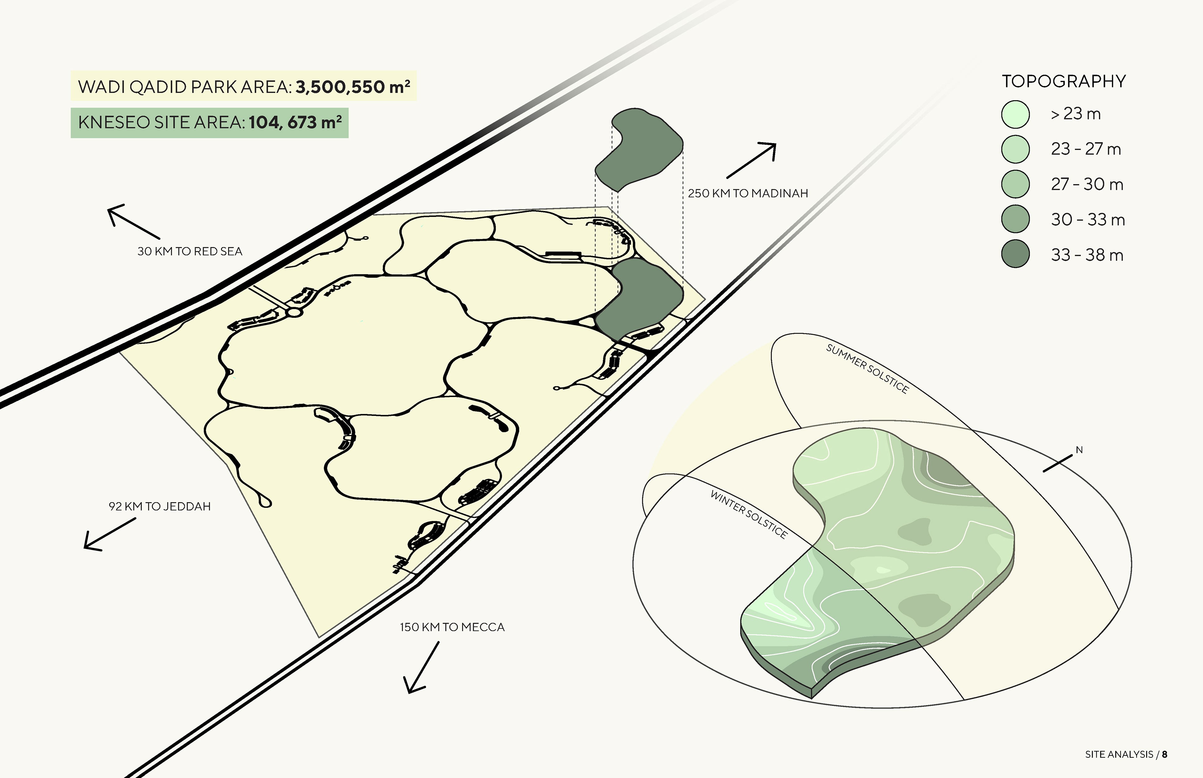
The experiment station is located on the future site of a 350-hectare national park located in Wadi Qadid – the Wadi Qadid National Park. Wadi Qadid is one of the 7 villages of the Khulais province in the Mekkah region, approximately 30 km from the Red Sea. Wadi Qadid is strategically positioned between three major cities in Saudi (120 km north of Jeddah, 150 km northwest of Mekkah, and 250 km south of Madinah). The area is of great historical importance due to its location on the Hijra migration route between Makkah and Madinah that was taken by the Prophet Mohammed. Before 1966, Khulais province was a groundwater abundant and fertile region with 70 to 90 operational wells, enabling the cultivation of vegetables, dates, and citrus crops. However, beginning in 1966 some of these wells were withdrawn to supply the city of Jeddah, which rapidly depleted groundwater supplies in the Khulais region and decreased agricultural activities. A lack of government services and investment in the Khulais province has resulted in the emigration of much of its population. Wadi Qadid has a population of nearly 6000 as of 2021. In 2021, Saline Water Conversion Corporation company in Rabigh extended the desalinated water pipes to several locations in the Makkah region, including Khulais. Residents of this area are still unable to access the pipeline water, though, and water access remains a critical challenge.
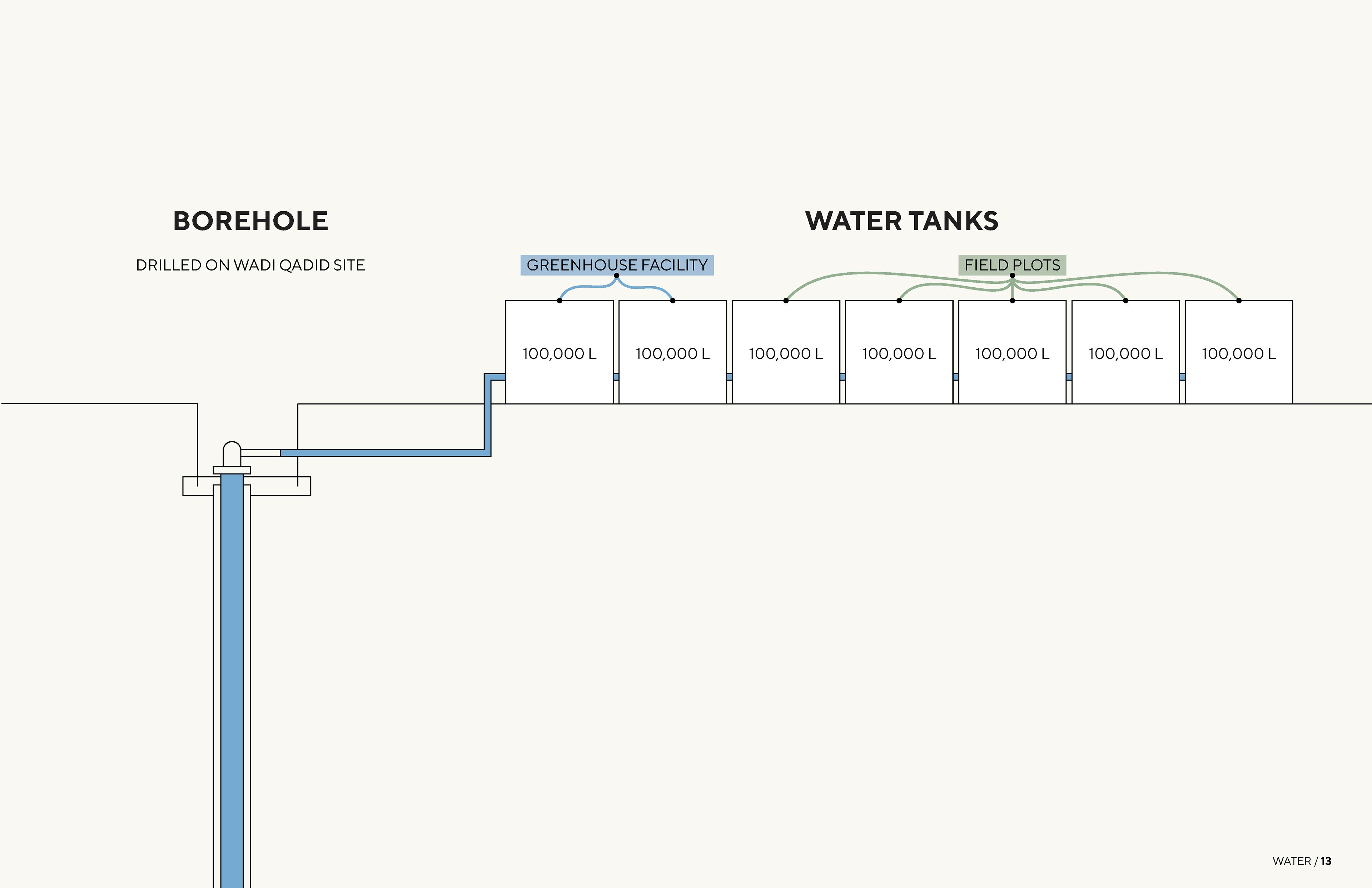
Research / Water
Due to the water scarcity of the region and the necessity to secure a water source to conduct agricultural research, it was determined that a borehole would be the most viable solution. A borehole is a very deep and narrow well that is required to reach the far depleted groundwater of the area. The draw of the borehole was the fact that it would require little to no additional energy to acquire water once it is installed. The energy required to pump the water to the surface would be provided by solar power generated on site. While the borehole is contributing to the already low water table of the area, it was determined a necessary cost in order to research drought-tolerant, resilient crops that could reinvigorate agricultural practices of the region.
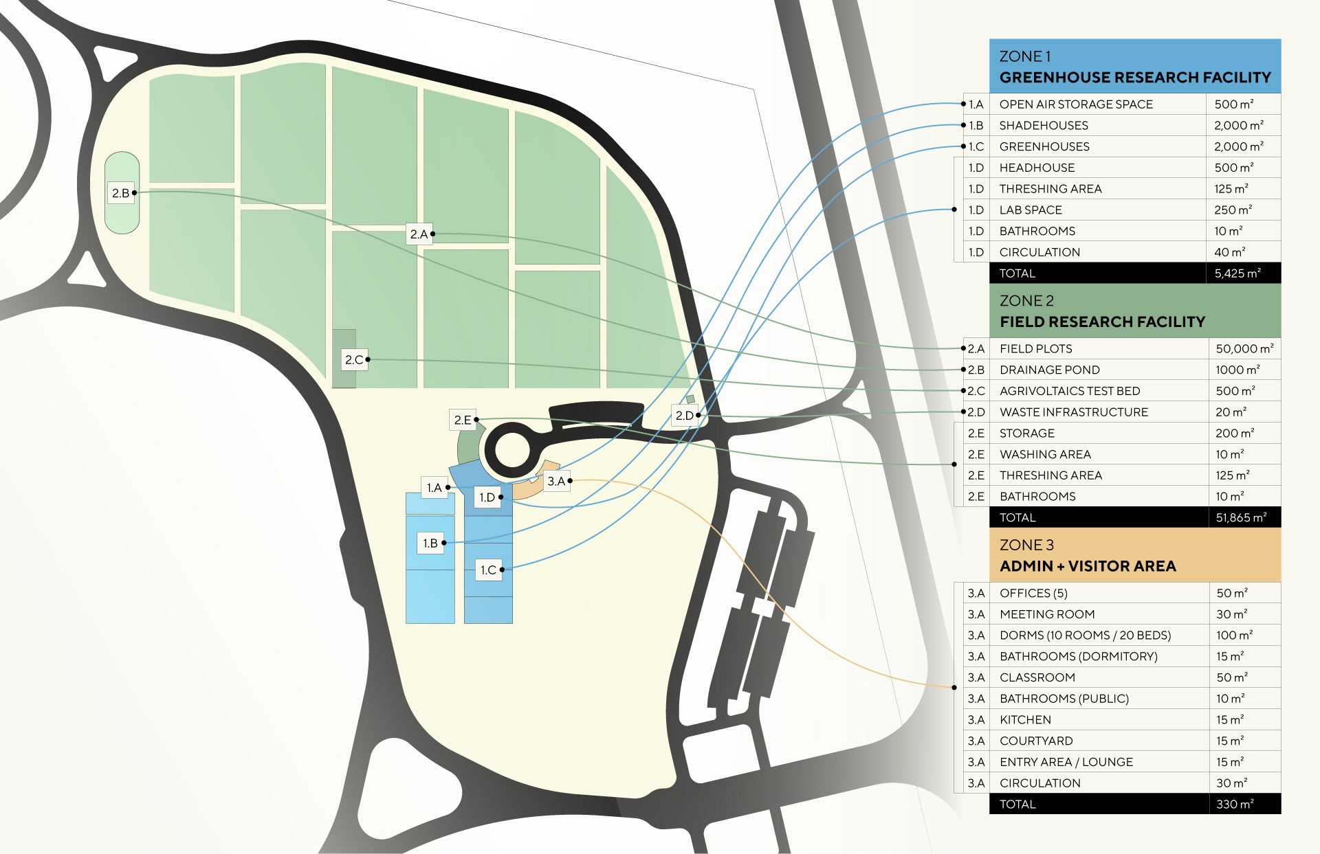
Research / Program
Using the University of Arizona’s Arizona Experiment Station (UA - AES) as a case study, I determined what programmatic elements were required and how much space they would need. Every programmatic element was filtered through the overall project vision to ensure that it was in line with the big-scale goals of the project; to create sustainable solutions for food, energy, and water of the region. Connecting the dots between the complex program created a web of relationships that served as the foundation of the site plan.
Design /Site Design
I mapped out the boundaries of the site provided by the masterplan of Wadi Qadid National Park. Since the field plots required 5 hectares of space, about 50% of the total site area, we determined the optimal location and orientation for this first. The north-west half of the site was chosen because of the relatively flat terrain for the field plots to have predictable movement of water and the gradual downward slope towards the drainage ponds that would use gravity to move the drainage water. Next, I determined how vehicles would access the site. Vehicle entry was placed adjacent to the highway to minimize travel time to the site once off the highway. Once inside the site, the road follows the edge of the field plots since those will be a main attraction of the site. The road leads to a roundabout that acts as the axis of activity for staff and visitors. Structures are strategically placed in a half circle to optimize for passive cooling, natural light, and to create a centralized hub. The adjacent greenhouse, shade house, and agrivoltaics test bed (solar panels over crops) are adjacent to the structures and optimized for maximum southern solar exposure. The remaining area of site is intentionally left open to plant native drought tolerant species combined with water harvesting earthworks to regenerate the water barren land.
Design / Proposal Design
After the creation of a schematic architectural masterplan, all information about the site’s history, potentials, and design was compiled into a single document that could be distributed to local stakeholders and presented by the CDA.
Result
Following the proposal, the project received 1 million USD in funding (as of March 2023). This initial investment has allowed phase 1 to be well underway as of February 2024. The concept map has been presented and shared to local stakeholders with great success in communicating the project vision and needs. There are currently temporary structures on site and people working to create the infrastructure necessary to start field research. Native species plantings have begun as a part of the Saudi 10 billion tree planting initiative. There are plans to have phase 3, the final phase of the project, underway by 2029.


© Copyright 2023. All rights Reserved.
Made in Framer